Mapping Kibera – A Visit To Nairobi's Slums

This post is part of the joint citizen journalism initiative “Citizen Journalism with Map Kibera During GV Summit“. The article was written by Salman Latif in collaboration with Rezwan and Juan Arellano.
Hundreds of bloggers, activists and academics from more than sixty countries gathered in Nairobi, Kenya last week for the Global Voices Summit 2012. One of the reasons of having the summit at Nairobi was to be able to interact with a number of local social projects and understand them better. One such unique initiative is Map Kibera, a project undertaken with the aim of mapping educational as well as health facilities in Nairobi's slums, Kibera. Please check out our case study on Map Kibera by Romina Oliverio.
Kibera is a very high-population-density region only miles away from the urbane settings of downtown Nairobi. The vast majority of the population in the region is very poor and can't afford even some of the basic necessities of life. Rape cases and instances other crimes are quite frequent, leaving hundreds of victims.
‘Map Kibera’ is a project that had been launched in collaboration with a number of youth from the locality. The aim of the project was to map education and health facilities in the region and to also highlight such regions on the map which are fraught with violence and where women run a higher risk of being violated.

Kibera On Open Street Map
The maps were first hand-drawn by youngsters from Kibera and were then digitized using different software. On the July 1, 2012, a groups of Global Voices members went to the neighborhoods of Kibera to meet members of Map Kibera while another Global Voices group went to visit Map Mathare. The Map Kibera team presented different aspects of the project on projector and listening to them having accomplished such an extra-ordinary feat was truly inspiring for us. Multiple maps have been created of the region, under the ‘Map Kibera’ project and these maps can be be critically important for different social projects as well as for the local population.
After having a detailed round of ‘Map Kibera’, the group of Global Voices bloggers and translators split into groups of twos and threes and ventured into the Kibera neighborhood to explore different issues. Me with two members of GV team (Juan from Peru and Rezwan from Bangladesh) grouped together with two members of the Map Kibera team and we decided to take a look at the educational institutions in the neighborhood.
There are two types of educational institutes in Kibera – informal or what we would usually call ‘private’ schools and formal or government-run schools.

A building of the Raila Education Center
To gauge a fair estimate of the educational facilities in the region, it was only natural that we visited both kinds of schools. So off we went, first to a rather famous public school known as ‘Raila Education Center’ named after the current Kenyan Prime Minister Raila Odingu.
The school was a fairly large facility offering both primary as well as secondary education. In the center was a rather huge football ground all set with state-of-the-art solar light. What struck as strange was that a lot of money seemed to have gone into the solar light, while the condition of the class rooms was abysmal. The windows were shattered, furniture, if any, was in a bad state and it all stood in stark contrast to the sleek, new-looking solar lights.
Since it was a Sunday, we had no hopes of running into an official we could talk to. However, we did run into a teacher who happened to be at the school while we were visiting it. We tried to talk to him but he simply refused to inform us about the school or the state of education at large citing that he needs permission to do so.
 Next we went to yet another school which was also a formal facility, called ‘Kibera Primary School.’ It was run by the City Council of Nairobi. Compared to Raila education center, it was in a lot better state. One of the best things about this school was that it had a separate section for handicapped students. While the classrooms were locked, we were able to sneak a peek in through the windows and they were fairly set with furniture and drawings.
Most of the facilities in the school, for instance the water supply, separate washrooms for handicapped and a lot more had apparently been funded by different organizations, as was manifest in the huge text that was plastered all over.
After spending some time in the school and waving to the dozens of children playing in the football ground, we left the facility and headed, finally, to an ‘informal’ or private school.
It was called the ‘Girls Soccer Secondary School’ and to make it to the school, we had to go through a very difficult path. We had been told that roads are nearly non-existent in Kibera and it was only then that we realized the true gravity of this.
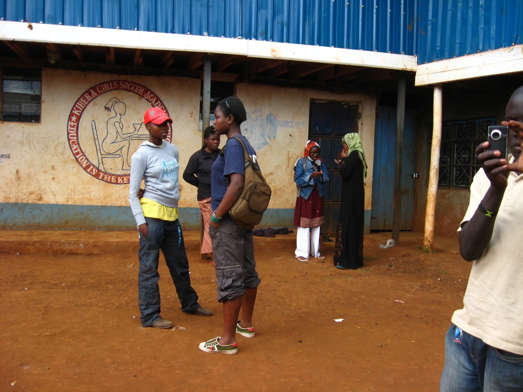
However, once we entered this school, everyone of us was overjoyed. Obviously a private school wouldn't have as many resources as a government-run school, still things seemed to be lot better in this school. It was smaller in size but we could see students with their books and bags wandering about the facility, even on a Sunday. A member of the Kibera team, also effectively our guide, told us that one could often see students on Sunday here, studying on their own.
Moreover, girls from this school also regularly secured position in the soccer team of the region, going on to play on higher levels. That was truly remarkable.
On our way back, we came across ‘Stara Rescue Center and School’ which was basically a place for such girls who have  suffered sexual abuse to stay in and be treated. Rape, we were told, is a common problem in Kibera. And since a lot of people can't afford to have toilets in their homes, women would go out at night and in that instant, would get raped. ‘Map Kibera’ is doing a remarkable job in this regard in that it is mapping all such regions where rape cases are more frequent so that women could avoid going to this place after dark.
In all, at one side, it was heart-rendering to note the situation in Kibera and how, merely miles away from the State House, the town was bereft of even the most basic necessities of life; and yet, on the other side, it was projects like ‘Map Kibera’ which somehow restored our faith in humanity.
[Images copyright Juan Arellano]